Phu Langka national park covers the area of
approximately 31,250 Rai in Pai Loam Sub-district, Ban Phaeng District of
Nakhon Phanom Province, and Seka District of Nong Khai Province. The area
includes layers of three mountains overlapping each other, interspersed with
small mountain ranges spreading along Mekong River. There generally are lush
forests such as dry evergreen forest, mixed deciduous forest and dry
dipterocarp forest which are habitats of abundant wildlife and watershed for
many streams. Best season to visit are from May to October when numbers of wild
flowers and orchids bloom on top of Phu Langka Mountain. Interesting sights
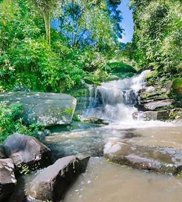
inside the national park include;Nam Tok Tat Kam is a four-tiered waterfall
surrounded by shady trees and a rock field, suitable for relaxation. The last
tier of the waterfall is filled with water all year round.Nam Tok Tat Pho
waterfall is originated from Phu Langka Mountain Range. As beautiful as Tat Kam
Waterfall, Tat Pho Waterfall is a four-tiered waterfall with more than 10
meters in height at each tier. The second tier is over 30 meters high. To get
there, take Highway No. 212 from Nakhon Phanom town, and turn left at the 214th
kilometer onto the route where you proceed for 3 kilometers. Nam Tok Tat Pho is
4 kilometers away from Tat Kam Waterfall. Three nature trails are available.
The first trail is Nam Tok Tat Pho-Tham Ya route, taking one hour and a half
for the distance of 1.5 kilometers. The second trail is Nam Tok Tat Pho-Pha
Ngoi route, taking one hour and a half to two hours for the distance of 1.8
kilometers. Unique feature of the second trail is a viewpoint on top of Pha
Ngoi where tourists can overlook the scenery of Ban Phaeng District and Mekong
River. The third trail is Nam Tok Tat Pho-Chedi Kong Khao Si Bun Nao route,
taking 2 days and 1 night to complete. Trekkers need to bring tent and bedding
for the journey, while the officials will prepare you food. Unique features of
this trail include the sights of various wild flowers, orchids, butterflies and
birds on top of Phu Langka and the Chedi Kong Khao Si Bun Nao which is a rock
field with a pagoda in the shape of a pile of rice, and the highest peak of Phu
Langka Mountain. After conquering the mountain peak, tourists can also enjoy
the stunning view of sunrise and sunset. (To go up Phu Langka Mountain's peak,
contact the national park office for a guide and carrier, 7 days in advance)For
the accommodation, Phu Langka National Park provides tent for 2-6 people and
area for camping. For more information, contact tel. 083-348-2549. To get
there, by car, from Nakhon Phanom town, take Highway No. 212, Nakhon Phanom-Ban
Phaeng route, for 105 kilometers. Turn left at the 220th kilometer, 6
kilometers away from Ban Phaeng District. Alternatively, take public buses,
Bangkok-Ban Phaeng, leaving Mochit 2 Bus Station on Kamphaeng Phet Road. Drop
off at Ban Phaeng District and take a motorcycle taxi to Phu Langka National
Park.